© Trunaev E.M.
Part 3
The new circuit of global
tectonics of the planets and their satellites.
Besides of the whole variety of geotectonic models, constructed by the plan of classical
representations of so-called "fixists" and "mobilists", the
fundamental problems of the common geodynamics, geomorphology (see " the list of
unsolved problems") and problems of historical geology basically haven't yet the
decisions. The nature of structures of ocean cavities and continents is unknown in
science, they have striking difference each from other. At the same time, there are the
problems of dynamic property. It is completely not clear to the scientists where the
continents move to and whether they do in general, and if they move what are the forces
the sources of energy. The widely distributed assumption that the cause of movement of the
earth crust is thermal convection is unpersuasively in basic, Since it has appeared, that
such assumptions go counter to the basic rules of many physical laws, experimental data
and numerous supervisions, including the data of space researches of tectonics and
structure of other planets. The real circuits of thermal convection, which do not
contradict the laws of physics, are not found, and the uniform logically reasonable
mechanism of movement of substance , which is equally acceptable for conditions of
entrails of stars, planets and their satellites, is not found till now too.
Below we shall consider a non-inconsistent circuit of
formation and evolution of the earth crust and firm environments of other planets and
their satellites which constructed outside of relation and without attraction of the
mechanism of thermal convection, the presence of which is at all unessential for normal
development of celestial bodies of any hierarchical level.
The "too hot" substance (magma) is formed
of combination of different sort of atoms of chemical elements, spontaneously arising in
the entrails of the pre-Earth cosmogenic vortex (and equal in entrails of other celestial
object of spherical form). All this substation is formed from the "new" atoms at
once they go from the southern mirror of an adiabatic magnetic snare, which is an end face
part of the cosmogenic vortex [see a part 2], and
therefrom the given substation begins the way already in new quality. The whole weight of
"too hot" substance, gradually passes in a spherical part of a magnetic dipole
taking root in it guided on course of presence of power lines of a geomagnetic field, and
here the substance spreads about the sphere, it is kept by a magnetic skeleton, and slowly
flows from one geomagnetic pole to other commensurate with a direction of the magnetic
meridians. It is natural, that some part of the substance, making the sphere, can appear
near to the surface. The thick coverings of rather quickly cooling down top mantle were
formed from this part of substance in the early pre-geological stage of development of
Earth, then atop of which the much more cold two environments - the crystal crust
and the atmosphere supersaturated with water ferry were formed. The water dropped out from
the last it gradually was condensed and formed the widths of uniform Global ocean. So the
whole surface of our planet was completely covered with water up to the end of the
pre-geological stage of development of Earth. At the same time, the rather active
volcanic activity proceeded in field of the southern nozzle in region of the
contemporaneous continent of Antarctica. The whole seas of lava were thrown up from the
entrails of vortex formation (core) of the planet, they were squeezed out on surface of an
original mouth - the so-called southern nozzle, here the structures of the basis (base) of
the unique pra-continent were formed from this substation, it lonely rose above the level
of the Global ocean, that has at once defined existing until now of the poles [fig.
3-a ][ 4 ] [ 5 ].
Just here, the "Pre-Cambrian" land masses
of crystal rocks of pra-continent were formed at the southern pole, in conditions of
space, limited with water of the Global ocean, they have a number of specific differences
from the structures, formed in the subsequent time outside of the surface of the southern
nozzle. Just here, the leaked forms of terrain, representing nowadays the so-called
Precambrian domes, the extensive saucer depressions and other sorts of "exotic"
elements of tectonics of "pre-Cambrian" could be formed in the extremely complex
and unique physics-dynamic and climatic conditions, commensurable with conditions of the
huge boiler with boiling porridge, they amaze the scientists with their abundance and
unique shape. Just here the masses of granite and the "ancient"
sedimentary-metamorphic complexes were formed in conditions of extremely high magma's
activity and raised(increased) migration of rather aggressive hot gases and high thermal
water solutions, sated with potassium, sodium, radioactive elements etc., They are the
evidence of bright and unique epoch of early development of the continents of the Earth,
epoch of formation of their basis (bases).
The structures of the continental great land masses -
leaders and outsiders stratificated during interval of time of duration about 700-800
million years in the field of the southern pole of Earth. The leaders are the
Canadian platform, Eastern-Siberian one and Eastern-European one. The outsiders are all
the others. The formation of the great land mass of the East Antarctica has finished the
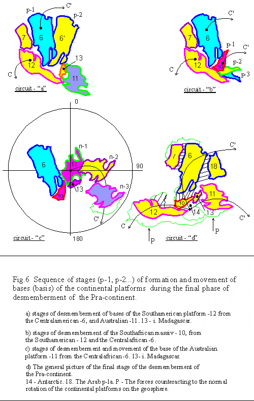
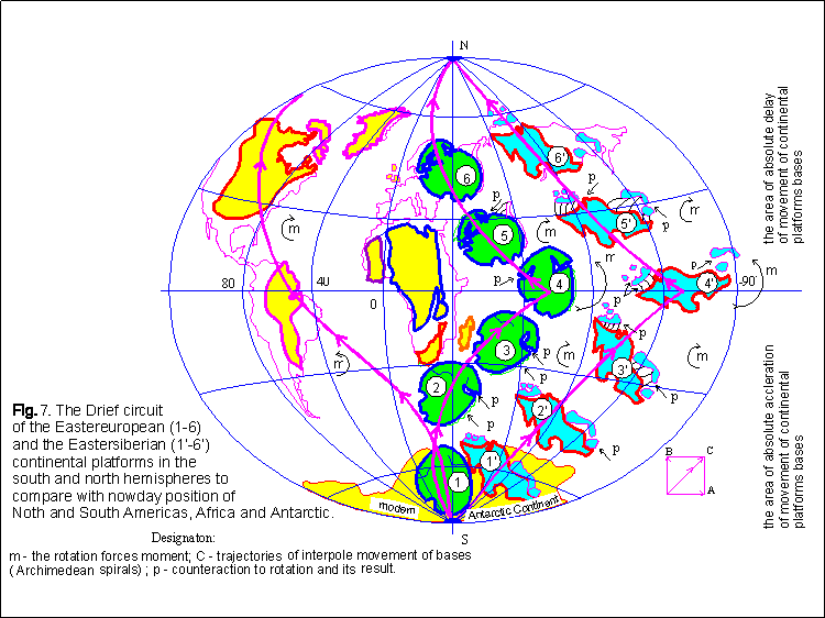
process [fig. 6 ] [ 7 ]. The same
type of physic-chemical, dynamic, climatic and other conditions, which existed in the
field of the southern pole in the whole duration of interval of time, while the basis
(bases) of the continental platforms - leaders were formed, and then the outsiders,
brought in the final result to the same geological attributes, on which now they try to
identify the so-called pre-Cambrian complexes.
Under influence of two opposite directed latitude
forces A and A' (Coriolis force and "waves of a tension") and so-called Force
Majeure - in determining interpolar, from the south for the north, current of substance of
mantle [fig. 3-c] the
pra-continent broke up on separated blocks of the bases of the continental platforms. The
newly formed structures separated from the southern pra-continent and, in accordance with
that, departured together with current of the mantle in direction of the northern pole.
The general sequence of such a movement was determined by condition of preservation of
dynamic balancing of the rotating geoid. In this case the pra-continent broke up on three
parts (branches), and each fragment, according to a principle of maintenance of balancing
of planet, was compelled to move by the individual trajectory, the common kind of which
has similarity to a line of Archimedian a spiral. By such a way three chains
("branches") of continental massif were generated conditionally named left,
central and right [ fig. 4 ][ 5 ][ 6 ].
The left branch formed the North American (Canadian) platform (with i. Greenland) and the
South American. The right branch formed the Eastern Siberian platform, the Chinese-Korean
one and the Australian one. And, at last, the Eastern European, Indostanian and
"parallel" to it the African platform, and the structures of the East Antarctica
formed one general branch - the central one.
In the Southern Hemisphere the trajectories of
movement of the continental platforms, making branches, go like a fan, following from the
southern pole to the northwest direction (left branch) and to the northeast (central and
right branch). In the Northern Hemisphere lines of all three branches converge from the
equator to the northern pole, twisting in one direction [fig. 3-c ][
4 ]
[5 ][ 7 ].
Depending on the character of a site of the curved of
a trajectory, on which the continental massif moves, size of angular speed and the
direction of normal (synchronous) rotation of the massif varies. And so the general kind
and the character of interaction of the massif file with the structures around varies. As
a rule, at the stage of primary difference of the continental bases in the field of the
southern pole, their rotation occurs with different angular speed and in different
directions (that is, there is the interaction by principle of different rotating gear
cog-wheels). And it means, that the most essential structural changes arise, primarily, in
the next areas of the bases themselves. Therefore all earlier cooperating massifs had the
appropriate adjustment of structure (shake out) of adjacent edges and transformation them
up to kind of opposite of structures, that is, when the ledge of one block precisely
enters in the groove of the other (see the contours of the continental platforms on [fig.
4 ][
5 ][ 6 ].
After the difference of the continental bases
finishes each massif passes in mode of independent navigation (interpolar drift). However
the general character of drift depends on influence of set of the collateral factors,
determined by action of different sort of the laws mechanics, including laws of
hydrodynamics (movement of fluid environments and their interaction with firm bodies). For
example, the general character of change of speed of movement of the basis of the
continental blocks depends not only on place of its situation on geosphere, but also on
size of general weight of the continent, on the sizes of its parts , on size of
"roots" (deep part of the continent determining size of "sail") of the
massif in drift and etc.. At the same time on the size of speed of drift
("translational" movement) the size of angular speed of own (synchronous)
rotation of the massif in drift depends. And the direction of such rotation depends on
being of the massif to particular branch of continental platforms, that is on the
character of distributions of their trajectories, and etc.. And, simultaneously, the
process of formation of structural infringements, connected with stretching or shift
(chipping, displacement, breaks, and etc.), on the back side of perimeter of the rotating
massif is defined.
The complete knowledge of these and other kinds of
movement of the continental massifs (following from the given concept), can serve as a
real base for determination (forecast) of places of concentration of mechanical pressure
and, it means, determination of the centers of earthquakes, for any region of Earth. And
the complete knowledge of the laws of formation and development of lithosphere of the
Earth, can promote more exact definition of conditions of formation and character of
bedding of mineral resources, and to promote the decision of other fundamental problems of
geology and geophysics.
A number of interesting reasons in
connection with the mentioned problems, the author can result in a more developed kind,
and also to participate in their practical embodiment.
|